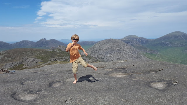
"I have seen landscapes, notably in the Mourne Mountains and southwards which under a particular light made me feel that at any moment a giant
might raise his head over the next ridge." -- C.S. Lewis
The Mourne Mountains are located in County Down, which comprises the most south-easterly county in both Ulster Province and in all of Northern Ireland. I can't recall when or in what context I first learned of the Mountains of Mourne, but I do know it was fairly recently -- within the last year, certainly -- and that I was immediately smitten. I pored over the Mourne Mountain pages at WalkNI.com and obsessed. I learned that C.S. Lewis spent holidays in the area in his youth, formative years, apparently, for he later attributed the real world magic of the Mournes as the inspiration for Narnia. What else could we do but get a copy of The Lion, the Witch, and the Wardrobe and take it with us on a journey to explore the Mournes?
Although the Mournes are the tallest mountain range in Northern Ireland, their total height is not terribly daunting: Slieve Donard, the biggest, is just 2,790 feet. However, they are immediately adjacent to the Irish Sea, meaning the elevation gain en route to peaks is not insignificant. Summits are criss-crossed by the historic Mourne Wall, an impressive feature constructed using dry stone techniques. The Wall is over 2 feet wide, almost 5 feet tall, and stretches for 22 miles. It is visible climbing over distant mountains, and serves as a handy navigation aid: just follow the wall to the top. Trees are rare in this landscape, with a patchwork of conifer plantations in valleys, but open highlands. Views abound in all directions. The openness makes the landscape seem vast, yet the compactness of the range renders it intimate.
I was initially tempted by Slieve Donard, of course. High pointing seems innate to me, instinctive. Yes, I want to climb the biggest mountain. But reading more, more, always more, I decided that some of the other peaks looked more interesting. Slieve Binnian, for example. It is the third tallest peak in Northern Ireland, and is topped with granite tors, giant rocky outcrops jutting into the sky. Erwin agreed. So it was decided. We flew a red eye into Dublin, arriving insanely early. Got a rental car at the airport and drove north. We stopped in the Town of Carlingford to get some breakfast and walk around. Walked around a bit more in Newcastle, then checked into our hotel, exhausted. Showered and had afternoon tea on the terrace with a view of the Mournes. A sweet welcome, indeed. After breakfast the next morning, our first full day, we stopped the grocery store for sandwich fixings, then set out for Slieve Binnian.
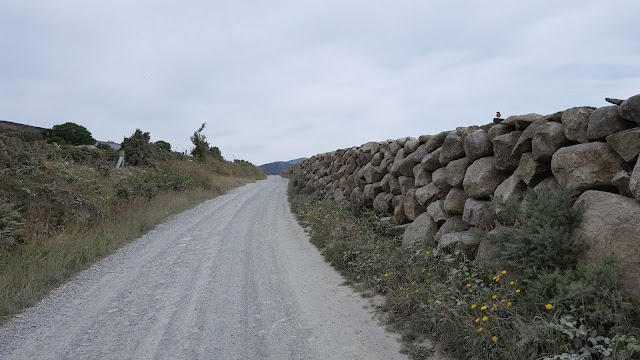
We started at the Carrick Little Car Park, walking north along a gravel road. This short stretch was extremely unpleasant because of the drought. Every time a car rattled by, we were stuck walking in a giant dust cloud. The plants along the roadside were grey with sediment.
We soon crossed a stile and left the cars and dust behind, first following a smaller track, then diverging left to follow the footpath along side the wall.
Navigation is easy on this hike: follow the wall up, aiming for the notch. There it is!
 |
| Wee Binnian |
We didn't need to cross this stile, but Frankie couldn't resist clambering up and crawling back through the sheep door. Then onward to the final ascent... and the last bit is steep.
 |
| at the notch |
 |
| summit views |
After eating and dancing and climbing the rocks on both sides of the notch, we finally started the gradual descent over the ridgeline to the north. We were immediately distracted by the Back Castles.
 |
| looking back at the summit |
 |
| fields of cottongrass |
 |
| the North Tor |
After passing the North Tor, the views down into the valleys began to open up. Blue Lough looked stunning. The descent down to the gap between Binnian and Slieve Lamagh is steep.
 |
| we are headed for the four-way intersection at the far right of this image, where we will turn right |
 |
| Slieve Lamagh and the Blue Lough |
 |
| finally down to the trail in the gap |
 |
| Blue Lough |
 |
| the path stretches far off in the distance, hugging the edge of the Annalong Wood |
I have very few pictures from the end of the hike. Erwin was getting morose about the thought of missing dinner, so somewhere between the Blue Lough and Annalong Wood, I stage-whispered to Frankie that we should try to beat his Dad back to the car, like we did in Bryce. The kid took off like a rocket! I thought he was perhaps a bit tired, but apparently not. He was full out running, across streams, over rocky ground, up hills. My mind was blown. I finally told him I couldn't run up any more hills and he conceded to slow to a fast walk. Whew! We did beat Erwin back, by several minutes despite his hurrying too, and made it back to Newcastle in time for an excellent dinner at Vanilla. Everyone was happy.
We followed the excellent map and guidance at WalkNI.com, which lists the total mileage as 7 miles. Everything was very straightforward. Elevation gain is probably about 2,000 feet.
And C.S. Lewis was right... the Mourne Mountains are truly magical.


No comments:
Post a Comment