For the second stop in my two-part adventure (part one here), I decided to hike Excelsior Gorge. The Finger Lakes Trail (FLT) passes through private land here, and part of it has a fall hunting closure starting November 1. It is also a fairly short off-road section, surrounded by roadwalks, so fit well into my mop up day. Plus, the weather was absolutely gorgeous today, sunny and dry, which seemed a good fit for Excelsior Gorge, given the warning for this section on the FLT Trail Conditions page, "Creek crossing (ford) can be extremely slippery." As I would find out, this warning is no joke. This is not a stream crossing to be taken lightly: I would not advise this hike for folks with impaired mobility or short legs. For example, I would not bring my Mom here. Or my nephew (not yet anyway).
I started this hike from the parking area associated with the boat launch on State Route 414, labeled "Seneca Lake Kayak" on the FLT mapping and Google Maps. I hiked north along the edge of the road, which wasn't super awesome, because it is a busy road with high speed traffic. But at least the shoulder is fairly wide, and after a while there is a guardrail with enough space to walk behind. Pedestrians walk into traffic, so I was on the left (west) side of the road. The FLT turns off the road on the east side. Look for the white blazes on the rock cut along the side of the road.
 |
hiking north along Route 414
|
 |
blazes marking the turn off the highway
|
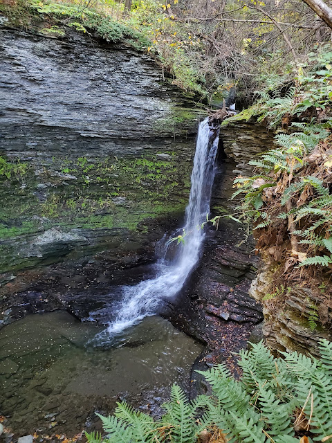
It is a very cool entrance to the hike, following the narrow trail around the rocks and leaving the highway behind. Double blazes mark a sharp right turn in the trail fairly quickly, climbing up a steep bank, but it is worth following the herd path straight a little further to check out the waterfalls.
I didn't continue off trail beyond the spot where I took the photo above, because I was on the right bank, which became very narrow and slippery. I turned back and found the double blaze marking the turn in the FLT, then followed it. There is a short climb and the trail briefly passes under the power line that runs along Route 414 before re-entering the woods. There is a partially screened view of the larger water fall through the trees from the trail as it ascends. The trail winds among additional rock outcrops, like the one pictured in the cover image, then continues to climb through mixed forest.
After cresting the hill, the FLT descends slightly toward the infamous creek crossing. The white blazes were a bit hard to follow in this area, but I was always able to find the track again after going astray. The beautiful stream in the picture below is the ford.


Very slippery, as advertised. Fast flowing water, with another
waterfall just downstream of the crossing. When
I read "ford" I expect to simply walk through the water, but that
wouldn't work here because the water was too deep and the rocks too
slippery. I concluded that the only way across would be to leap the span, and I was definitely somewhat intimidated. I knew I have the range to jump that distance; it was the narrow and slippery landing that concerned me. Would I simply slide backwards into the stream? In the end I decided to go for it, planning to lean my weight forward onto the rocky shelf to keep my center of gravity away from the water. And it worked fine! I think it would have been less intimidating for me had I not been alone. Older kids could make the jump, perhaps with a hand from their adult to help stick the landing.
 |
jump here!
|
 |
safely across, looking back at the trail down to the stream
|
 |
another view back at the crossing from the far side
|
After crossing the stream, the trail is much more straightforward, back to being a nice walk in the woods. Phew! When I came out to the trailhead on Jolly Road, I transitioned to the roadwalk portion of the hike. I turned left and followed the white blazes west along Jolly Road until I hit Route 79, which the FLT follows south for approximately 0.2 miles before turning north onto Route 414.
 |
approaching Jolly Road
|
 |
looking east at the trailhead along Jolly Road
|
 |
hiking west on Jolly Road
|
 |
double blazes marking the turn left/south on Route 79
|
 |
hiking south on Route 79; the FLT turns right ahead onto the road toward Ovid
|
 |
hiking north on Route 414
|
I only hiked north on Route 414 for a short distance, until reaching the intersection with Middle Road, pictured below. The shoulder is very wide here, and it seems like it might be a good place to park for the roadwalk to Twin Tunnels, which is long enough I will probably leave it for hunting season. From here I followed Route 414 back to the parking area, including the 0.3 mile non-FLT section just north of the entrance into Excelsior Glen.
 |
my turnaround spot at the intersection of Route 414 and Middle Road
|
 |
heading back south on 414
|
The FLT continues into the Village of Watkins Glen, leaving Route 414 at the south end of the boat launch parking lot. I had a little extra time before I needed to start the drive home, so I decided to continue a bit further. The trail here includes a nice footbridge over the Seneca Lake Inlet, after which it enters the well-groomed Clute Park.
It felt sort of surreal to be following FLT blazes through such a
domesticated landscape: gravel paths and mowed lawns and picnic tables,
oh my. There is even a small swimming beach.
I followed the FLT to the far end of the park, then scrambled up the highway embankment to the bridge over the barge canal. Running low on time now, I turned back here. I'll have to pick up the rest of the walk through the village on another outing.
 |
a last look north up Seneca Lake
|
GaiaGPS tracked this outing at 4.1 miles, including the short non-FLT roadwalk and my diversions in Excelsior Glen to check out the waterfalls and get back on trail when I veered off. An absolutely glorious fall day! While on the first roadwalk, I felt a bit of doubt, like perhaps I was squandering the perfect hiking conditions on a highway, but once I got into the Glen, I was very glad I had come.


No comments:
Post a Comment