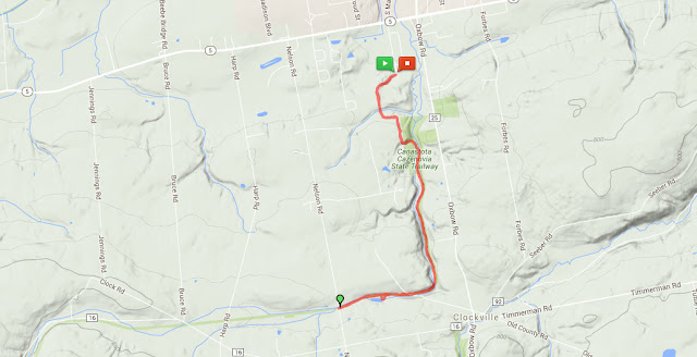
We had a spring snowstorm a few days ago, and lingering cold temperatures have kept the snow from melting. I had a couple sections of the North Country National Scenic Trail (NCT) on deck, and since I knew trails would be slippery in the steeps, I selected a segment with little elevation change. I headed further east than I'd previously been on the NCT to start my hike, to the outskirts of Canastota. The North Country Trail Association has designated Canastota as an official Trail Town, but I always skip the road walks, so I headed to the small parking area at the entrance to Mount Pleasant Cemetery. The trail winds through the woods on private land, briefly follows an old road, then veers back in the woods as a lovely single track.
A long wooden staircase descends into a ravine, with a bench and trail register on a landing encouraging a stop to enjoy the lovely scene. The trail follows an unnamed tributary of Canastota Creek for a short distance, then crosses the main channel of the creek over a sturdy wooden footbridge. There is another smaller bridge crossing another tributary, then the trail climbs back out of the ravine and joins the old Lehigh Valley Railroad bed, which it follows south for many miles.
Although rail trails are always wider than I prefer, this section is more interesting than many because of the bends in the trail and the slight grade change; at least it's not completely straight and flat. However, the rail trail is also marked as a snowmobile trail, so it may be a whole lot less pleasant in the winter. Canastota Creek adds visual interest, visible in the ravine below for almost a mile, then directly adjacent to the trail when the terrain becomes more gentle. About 2 miles out, the trail passes Canastota Reservoir, and some small cascades at its outlet. From here, it's a straight shot out to Nelson Road, which was my turn around point for the day. There is a small parking area along the shoulder, with room for a few cars, so I'll probably return here at some point to explore the next section of trail.
My phone tracked the hike as 4.8 miles roundtrip with 248 feet elevation gain.
 |
| Mount Pleasant Cemetery trailhead |
 |
| frozen honeysuckle (Lonicera sp.) leaves |
 |
| blue cohosh (Caulophyllum thalictroides) and Christmas fern (Polystichum acrostichoides) |
 |
| foot bridge over Canastota Creek |
 |
| Canastota Creek |
 |
| the old Lehigh Valley Railroad bed |
 |
| the sun appeared briefly |
 |
| early meadow rue (Thalictrum dioicum) |
 |
| trout lily (Erythronium americanum) |
 |
| looking back the way I came from my turn around at Nelson Road |
 |
| box elder (Acer negundo) |
 |
| Canastota Reservoir |
 |
| hepatica (Anemone acutiloba) |
 |
| gooseberry (Ribes sp.) leaves in the snow |
 |
| I brought an empty pack this time to carry my extra layers |
 |
| white trillium (Trillium grandiflorum) |
 |
| back at the cemetery |


No comments:
Post a Comment