This hike is the reason we came to Scotland. No joke! Our trips are often inspired by some insignificant detail that leads down a rabbit hole of investigation and obsession. For example, Erwin and I traveled to St. John's many years ago after I saw a job listing for a biological science technician position with the Park Service, but couldn't apply because it required scuba certification. At the time, I had the same job title working for the Forest Service. I knew nothing of St. John, but was very interested in what I read as I burrowed away. A Caribbean island not dominated by golf and casinos? What? Similarly, our trip to Ireland was spurred by some rare plant surveys I did for Hart's-tongue fern (
Asplenium scolopendrium var.
americanum). While doing background research, I discovered that another variety of this federally threatened species is common in Ireland; once I read about the Burren, there was no turning back. My Quiraing fascination grew along those lines.
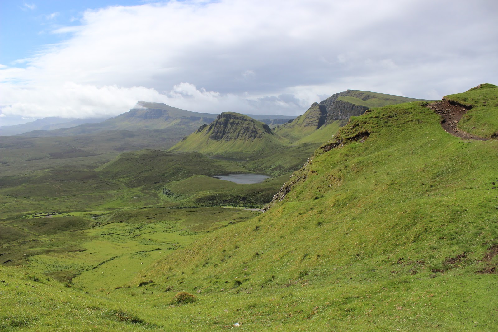
I happened to see a picture of the amazing Quiraing landscape a few years ago, and the obsession began quietly simmering. After roasting in the heat of Italy last summer, I vowed our next big trip would be somewhere with cooler temperatures. Somewhere like Scotland! The Quiraing is located on the Trotternish Peninsula, at the northern end of the Isle of Skye, which is nestled between the Outer Hebrides and the Highlands. Skye is rugged and spectacular. We spent a week here and it was not remotely enough time. I truly love this place! I feel so comfortable here; simultaneously comfortable and awed, which is a great combination.
We used Walkhighlands again to plan the hike. We were in such a rush to get out that morning we forgot to bring any maps, which stressed me out to no end (and was a mistake we did NOT repeat on other hikes). However, the main trail below the escarpment is well defined, and we were able to complete the circuit from memory, albeit inadvertently in the reverse direction
described. This worked out fine though, since torrential rains pounded us for the last part of the hike; going backwards allowed us to pass through the most dramatic sections in comparatively good weather. We stopped for a picnic lunch on the slopes above a tiny little rush-filled pond about 3/4 of the way north, then clambered through another charming rock garden, passing a cairn marking a trail junction before climbing the steep slope to a col in the escarpment. Here was another split, with the right fork going northeast, apparently to a viewpoint above Flodigarry, and the left fork turning south and climbing further up the escarpment.
Due to various concerns, we almost turned back here and retraced our steps back the way we came. I was worried about the lack of maps, afraid we'd accidentally end up on the much longer Skye Trail or Trotternish Ridge Trail. Erwin was feeling a lot of anxiety about the wind, which had knocked Frankie off his feet once already, and had only strengthened up on the cliff top, where the consequences could obviously be much greater. We decided to risk moving forward, since the trail very clearly headed south along the cliff top in the direction expected (back toward the car). Given that I had positioned myself between Frankie and the cliff top, and was holding his hand tightly, I wasn't too worried about the wind, but I offered to move further away from the cliff as a concession to Erwin's anxiety. This made for somewhat trickier footing through the hummocky heather, but was totally worth it for his peace of mind. Being upslope of the cliff edge, we missed the some of the views downward, but the rain was pounding by the time we got to the area above the Table, so I'm not sure what we would have seen anyway.
The circuit is 4.5 miles with about 1,100 feet elevation gain. Rain or no rain, I would repeat this hike any time. It is simply breathtaking!
 |
| photo by Erwin |
 |
| photo by Erwin |
 |
| photo by Erwin |
 |
| photo by Erwin |
 |
| photo by Erwin |
 |
| photo by Erwin |


No comments:
Post a Comment